


la remué bois tancarville

doboul
User
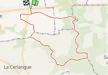

Length
9.9 km

Max alt
127 m

Uphill gradient
116 m
Km-Effort
11.4 km

Min alt
35 m

Downhill gradient
116 m
Boucle
Yes
Creation date :
2021-04-08 15:44:06.974
Updated on :
2021-04-10 08:28:12.565
2h35
Difficulty : Easy

FREE GPS app for hiking
 SityTrail
IGN / Geographical institutes
SityTrail Plus
The world is yours!
About
Trail On foot of 9.9 km to be discovered at Normandy, Seine-Maritime, La Remuée. This trail is proposed by doboul.
Positioning
Country:
France
Region :
Normandy
Department/Province :
Seine-Maritime
Municipality :
La Remuée
Location:
Unknown
Start:(Dec)
Start:(UTM)
313495 ; 5489422 (31U) N.
Comments